Saturday, November 29, 2008


updated 1 hour, 29 minutes ago

New rifts form on Antarctic ice shelf

  • STORY HIGHLIGHTS
  • Scientists have identified new rifts on an Antarctic ice shelf
  • The Wilkins Ice Shelf is connected to two Antarctic islands
  • Scientists first spotted rifts in the ice shelf in late February
  • Next Article in World »
Decrease font
Enlarge font

(CNN) -- Scientists have identified new rifts on an Antarctic ice shelf that could lead to it breaking away from the Antarctic Peninsula, the European Space Agency said.

A satellite image of the Wilkins Ice Shelf, which could break away from the Antarctic Peninsula.

A satellite image of the Wilkins Ice Shelf, which could break away from the Antarctic Peninsula.

The Wilkins Ice Shelf, a large sheet of floating ice south of South America, is connected to two Antarctic islands by a strip of ice. That ice "bridge" has lost around 2,000 square kilometers (about 772 square miles) so far this year, the ESA said.

A satellite image captured November 26 shows new rifts on the ice shelf that make it dangerously close to breaking away from the strip of ice -- and the islands to which it's connected, the ESA said.

Scientists first spotted rifts in the ice shelf in late February, and they noticed further deterioration the following week. The period marks the end of the South Pole summer and is the time when such events are most likely, said Ted Scambos, a glaciologist at the National Snow and Ice Data Center at the University of Colorado in Boulder.

Before the new rifts were spotted this week, the last cracks were noticed July 21.

"These new rifts, which have joined previously existing rifts on the ice shelf, threaten to break up the chunk of ice located beneath the 21 July date, which would cause the bridge to lose its stabilization and collapse," said Angelika Humbert, a scientist from Germany's Muenster University who spotted the cracks with Matthias Braun of the University of Bonn.

Wilkins is the size of the state of Connecticut, or about half the area of Scotland. It is the largest ice shelf on the Antarctic Peninsula yet to be threatened.

If the ice shelf breaks away from the peninsula, it will not cause a rise in sea level because it is already floating, scientists say.

Scambos said the ice shelf is not currently on the path of the increasingly popular tourist ships that travel from South America to Antarctica. But some plants and animals may have to adapt to the collapse.

The ice shelf had been stable for most of the past century before it began retreating in the 1990s.

Several ice shelves -- Prince Gustav Channel, Larsen Inlet, Larsen A, Larsen B, Wordie, Muller and Jones -- have collapsed in the past three decades, the British Antarctic Survey said.

Scientists say the western Antarctic peninsula -- the piece of the continent that stretches toward South America -- has warmed more than any other place on Earth over the past 50 years, rising by 0.9 degrees Fahrenheit each decade.


Friday, October 31, 2008

TESTING CLASSICAL ENIGMAS


As geoscience edges closer to answering the riddle of “Strabo’s Channel” it may also solve one of the greatest mysteries in western literature, writes John Underhill*.


Geoscientist 18.9 September 2008


Editor's note: The web version of this feature does not contain all the figures present in the print version. This is for a combination of space and technical reasons. Omitted figures are indicated in the text and captions. Captions are viewed by rolling your cursor over the figure. This system does not allow lengthy captions, so some have been abbreviated. For full captions please refer to the print version. NB: this captioning function does not work if you are using Mozilla Firefox as your web browser. For full functionality please switch to Internet Explorer. Ted Nield
Figure 1: Islands of W. Greece. The disposition of modern Ithaki and its nearby islands and the Paliki peninsula (W. Kefalonia). Distances A and B, quoted by Strabo in stades, are converted to kilometres and compared with today’s measurements.
Figure 2: Aerial photograph of the Thinia isthmus on Kefalonia. The surface of the central area of the isthmus consists mainly of loose rockfall and landslide debris. Photograph by Robert Bittlestone. The location of Homer’s enigmatic isle of Ithaca has puzzled scholars for over 2500 years. True, an Ionian island called Ithaki exists today off the western coast of Greece (Figure 1). But with a vertiginous coastline and high topography, facing east and standing nearest to the mainland of a group of three islands, it directly contradicts a key passage from the Odyssey describing Odysseus’ homeland as furthest out to sea of a group of four islands, low-lying and “facing the dusk” (i.e. west)1.

In 2003 Robert Bittlestone proposed a solution to this conundrum by suggesting that at the time of the Trojan War 3200 years ago, the low-lying western peninsula of Kefalonia (Paliki) had been an island. This idea demanded that a land bridge linking Paliki to the rest of Kefalonia had arisen since that time – posing a considerable geological challenge. Previous accounts of the project in which I and Cambridge University classicist James Diggle have been engaged were published in the book Odysseus Unbound2 and in Geoscientist 3,4,5. The present article provides an update on progress since March 2007, when geoscience company Fugro agreed to sponsor the geological investigation using the latest land-based, marine and airborne technologies.
Figure 3: Geological surface survey of Thinia isthmus. The original two-dimensional survey diagram has been rendered by a digital elevation model (DEM).

Strabo’s Channel


In his 17-volume Geography, composed some time in the first two decades of the Christian era, the Greek writer Strabo described the known world, employing an astute combination of personal observation and other travellers’ reports. Describing Kefalonia he wrote:

Cephallenia lies opposite Acarnania, at a distance of about fifty stadia from Leucatas (some say forty), and about one hundred and eighty from Chelonatas. It has a perimeter of about three hundred stadia, is long, extending towards Eurus [east or south-east], and is mountainous. The largest mountain upon it is Aenus, whereon is the temple of Zeus Aenesius; and where the island is narrowest it forms an isthmus so low-lying that it is often submerged from sea to sea. Both Paleis and Crannii are on the gulf near the narrows6.

This 2000 year-old description contains some surprisingly precise and accurate measurements (Figure 1) 7 . These inspire confidence in the veracity of Strabo’s reference to a low-lying narrow isthmus near Paleis and Crannii that is often (but by implication, not always) covered by the sea from end to end. The location of these two settlements is not in doubt since they are still visible today. Strabo therefore provides independent reference to a marine channel in just the right place to make an island of the Paliki peninsula – a place now occupied by the isthmus of Thinia.
Figure 4: Satellite image of the Thinia isthmus, Kefalonia. Copyright: Google Earth/Digital Globe
So the notion of a buried marine channel that existed in the 13th Century BC is supported by a separate and much later historical reference, and is clearly testable using modern geoscientific methods. Over the past three years, field geology, geophysical techniques and geomorphic methods have therefore been deployed to test the theory.

Geological setting


The Thinia valley is approximately 6km long, up to 2km wide and rises to around 180m in its central saddle area (Figure 2). It is bounded on either side by steep hill ranges, rising to almost 1km on its eastern flank. Geological field studies show that Thinia may be separated into two distinct parts. The western area consists of a largely stratigraphically conformable but tilted, gently folded and locally thrusted (para-autochthonous) succession of Cretaceous and Paleogene limestones, unconformably overlain by Miocene marls and clastic sediments dipping gently eastward. In the eastern area, Cretaceous and Paleogene limestones dip very steeply westward (Figure 3)8. The boundary between the two provinces is the Aenos Thrust, which has emplaced the westerly-dipping Cretaceous-Paleogene limestones of the east onto the easterly-dipping Miocene sediments of the west (though its trace is largely obscured by rockfall debris).

The steep (45° - >60°) westerly dips seen on the east side of the valley are the result of their forming the western limb of a major hanging-wall anticline as a natural consequence of thrust emplacement. The eastern hillslopes along the Thinia valley are highly unstable and catastrophic collapse as a result of bedding-plane failure is common, with many of the steeply-dipping bedding planes showing evidence (e.g. slickensides) of down-dip (flexural) slip.

If Strabo’s account is accurate then as recently as 2200 years ago this isthmus, in places now 180m above sea level, was “often submerged from sea to sea”. The key questions are therefore:
  • What geological mechanism could have caused the infill?
  • What did Strabo mean by “often”?
Figure 5a: Mass wastage at Myrtos Bay. (Location: see Figure 4.). Photograph by John Underhill.

Tectonic instability


On a regional scale Kefalonia lies at the NW extremity of the Hellenic Subduction Zone, along which collision between Eurasia and Africa is taking place. Kefalonia is the most seismically active part of western Greece and is experiencing outer-arc uplift. Plio-Pleistocene sediments exhibit significant neotectonic deformation9.

The island is being thrust up by major earthquakes (M >7.0) occurring on average once every 50 years. On 12 August 1953 a magnitude 7.2 event uplifted much of the island by about 60cm, and there is growing evidence (from marine notches and raised beaches) of tectonic uplift of up to six metres having taken place (relative to sea level) over the last few thousand years. Although co-seismic upthrust is significant, the fact that the valley’s central saddle stands so high (Figure 2) clearly rules it out as a primary factor – but there are other factors at play.

Figure 5b: Deposits of mass wastage due to cliff failure, NE of Agia Kiriaki bay. (Location shown in Figure 4.). Photograph by Robert Bittlestone.

Slope failure


Triggered by powerful earthquakes, Thinia valley’s unstable eastern slopes often generate rock avalanches today and there is clear field evidence for major rockfalls and landslides in this area. Widespread boulder-strewn slopes are common, many involving high-volume mass wastage in which large sections of the mountainside have detached from underlying strata during the late Holocene.

Figure 4 is a satellite image of the isthmus in which the blue lines indicate unstable hillslope edges. Yellow and green lines show the most likely eastern and western boundaries for any buried channel, based on serial cross-sections, slope geometry and an extensive surface survey. The location of the narrow southern end of this potential channel route is closely constrained by the adjacent limestone strata, but the surface geology of the much wider northern segment at present suggests several possible channel routes for geoscientific evaluation.

Several spectacular examples of collapse characterise the coastline to the north of Thinia (Figures 5a & b). The photograph in 5a shows a large, unstable detached (olistolith) block on the eastern cliff of Myrtos Bay. The car highlighted for scale gives some idea of the mass involved. Figure 5b shows how contemporary cliff failure has narrowly avoided destroying the coast road. Much of the debris from this fall has already been washed out to sea here because the base of the cliff is unconfined.

The landscape on the eastern side of the Thinia valley consists mainly of loose, pulverised debris that has descended catastrophically from the mountains above. A major, isolated westerly-derived rockfall deposit also sits at the northerly end of the isthmus beneath the village of Zola. In several instances, extensive rockfall and landslide deposits have cut off roads and carried away houses (Figures 7 & 13).

Figure 6a shows the scale of the eastern mountain range above Nifi village. As well as the effects of high-altitude co-seismic hillslope failure, this village also suffers from local landslides which can take place without help from earthquakes in wet conditions. The last such event occurred in November 2007 and destroyed several houses (Figure 6b & c). Further to the south of the island, the August 1953 earthquake triggered several major cliff collapses3.
Figure 6a: Gravitational potential for mass wastage at Nifi (Thinia valley). Photograph by Robert Bittlestone.

Geoscientific tests


Earlier land-based research work had focused upon geological mapping. The results highlighted the importance of rockfall debris strewn across large parts of the valley, particularly below its eastern slopes (from which most of the material evidently derived - Figure 3). However, it soon became clear that the existence of a buried marine channel could not be determined purely from surface geology, although field mapping alone has been relied upon in previous studies11,12,13. The only way of determining whether the Thinia rockfalls had infilled a former marine channel was to produce a 3-D view of the subsurface along the entire length of the Thinia valley. This demanded the drilling of a preliminary borehole and the use of geophysical methods and sampling to calibrate the subsurface data.

Figure 7 shows the location of a test drilling (October 2006)4. Although the borehole site was bordered on east and west by bedrock limestone, the surface material there consists of loose rockfall running north-south. The location sat 107m asl. and a 122m borehole was drilled (i.e. to 15m below today’s sea level) without encountering any solid limestone.
Figure 6b: Catastrophic landslide at Nifi (Thinia valley), November 2007. Photograph by John Underhill. Significantly, the marine microfossil Emiliania huxleyi was found admixed with older, loose rockfall sediments within the top 40m of the drill hole. This single-celled phytoplankton (coccolithophore) could not have reached this location earlier than about 6000 years ago, when rising global sea levels penetrated the shallow Gulf of Livadi for the first time. So how did this recent microfossil become embedded within loose rockfall material 40m below today’s surface?

One explanation could involve the chaotic intermingling of a high-volume rockfall with the waters of a confined marine channel. Alternatively it could be that the wind-blown products of a marine bloom had already been deposited on the pre-rockfall surface and were subsequently incorporated into loose sediments during a rockfall. Whichever the explanation for its presence, it is clear that rockfalls have indeed buried a substantial ancient relief with sediments that must date from the late Holocene.

After drilling, gamma ray and resistivity were measured through well logging. These were compared to cutting samples and to onsite geomorphology. That integration enabled the relationship between the drill site and geology to be assessed accurately and a cross-section to be constructed showing the underlying strata at this location (Fig.8). The borehole drilled through 40m of rockfall material before encountering a Miocene marl boundary on the east of the diagnosed channel sidewall.
Figure 6c: Newspaper report: “Nifi’s Night of Horror: sudden catastrophe drowns 4 houses in mud” In February 2007 the geotechnical, survey and geoscientific service company Fugro became the project’s principal sponsor, which includes a Natural Environment Research Council (NERC)/CASE-sponsored PhD studentship based in the School of Geosciences at The University of Edinburgh. The collaboration has brought in substantial land, sea and airborne resources. A successful field campaign during in the second half of 2007 has now generated much new, high-quality data.

Field teams from Fugro and Edinburgh University have conducted resistivity, seismic refraction and gravity surveys in key areas. The integration of these geophysical techniques has afforded excellent resolution of the buried bathymetric profile of an ancient lake bed, termed Lake Katochori, lying to the west of the proposed channel route (Figure 9). As a result it has become clear precisely where to drill shallow boreholes in order to obtain a core from which radiocarbon dating of the oldest sediment (i.e. from the deepest part) of the former lake can take place. If most of these sediments prove to be younger than c. 2200 years old, then this will support Strabo’s observations. If they are older, the hypothesis will have to be reconsidered.

Other gravity lines located across the eastern side of the valley have yielded some intriguing negative Bouguer anomalies. Although these seem consistent with the presence of a buried channel, there are currently insufficient data to make a rigorous assessment. In addition to a follow-up gravity survey planned for the eastern area and a shallow drilling programme in Lake Katochori and infilled coastal plain areas, the next land-based stage may involve acquiring seismic reflection data along and across the possible route of the buried marine channel. Subject to results, the intention would be to drill additional deep boreholes in the saddle of the valley, where the proposal is most severely challenged – namely at the narrowest boundaries and highest elevations. Radiocarbon dating of core samples from these locations is expected to provide a definitive assessment of the composition and age of the valley fill, down to sea level and below.
Figure 7: Diagnosed southern exit of Strabo’s Channel. Yellow, green lines - see Fig. 4. Red arrow - borehole drilled October 2006 at the southern limit of interruption (by rockfall and landslides) of a track that re-emerges 800m to the north. 
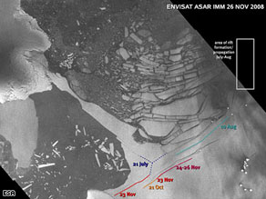
Fugro Airborne Surveys of Canada have performed an aerial electromagnetic survey of the Thinia valley using a multi-frequency transmitter/receiver attached via a cable to a helicopter and flown at low altitude over Thinia and northern Paliki (Figure 11 - omitted for space reasons. See print version), producing detailed maps of resistivity and magnetic susceptibility. Figure 12 maps near-surface ground resistivity measurements from this survey (which achieves a subsurface penetration of c.90m). Blue and dark green colours (resistive) correspond to limestone bedrock. Light green and yellow represent marl, conglomerate and loose rockfall. Orange and red represent conductive sea water or saline-saturated sediments. Uncoloured areas are villages that were not overflown. From this it is clear that the Thinia valley consists mainly of low resistivity material (i.e. marl, conglomerate and rockfall debris) down to at least 90 metres. However, because much of the central section of the valley stands higher than 90m asl, this is supportive rather than conclusive evidence as far as the theory is concerned.
Figure 8: Test Borehole. The upper image shows the borehole location relative to Figure 7 (print version only); the lower diagram indicates the underlying geology. Fugro has also used its FLIMAP laser tele-altimetry technique to highlight areas where slope failure has occurred - especially where this is not always obvious from ground survey alone. FLIMAP provides helicopter-based photographic mapping and laser terrain elevation measurement, and as a result the project has access to an unprecedented array of digital maps, elevation models and photographic imagery of the terrain, to an accuracy of a few centimetres. This supports field observations that catastrophic (probably co-seismic) failure of the western slopes has destroyed the walls of human settlements. Remnants of former habitation (including houses with tiled roofs) occur within landslides located downslope (Figure 13). Such dramatic evidence of hillslope collapse may enable us to assess not only the volume of mass wastage triggered, but also its approximate date, using cosmogenic isotope dating techniques.
Figures 9 b&c (9a - a photo - omitted in web version) 9b, top: W-E striking resistivity line. 9c: Seismic refraction line at Lake Katochori.
We hope that Fugro NPA Limited’s field-based laser scanning (LIDAR) site surveys and satellite-borne Interferometric Synthetic Aperture Radar (INSAR) methods can be deployed as part of the project to quantify these slope movements, which could potentially also provide input for early warning of slope instability.
Figure 9d - the resulting resistivity map defining the sedimentary fill at Lake Katochori. Fugro’s Italian-based marine subsidiary Oceansismica has conducted a detailed survey of the coastal waters both south and north of the Thinia isthmus, using state-of-the-art high-resolution marine seismic reflection and side-scan sonar (Figure 14 - ommitted, technical reasons. See print version). This has generated a large quantity of marine data, currently undergoing interpretation. It has thus become possible for the first time to investigate not only the buried Holocene sediments, but also their basal unconformity and the Hellenide (Alpine) structures affecting the bedrock (Figure 15).
High resolution analysis of the buried, sub-Holocene erosional surface (Figure 16b) has confirmed that the area of deepest marine bedrock is indeed aligned with the diagnosed southern exit of “Strabo’s Channel” (Figure 16a). The fidelity of the new data highlights the submarine structure and also the alignment between terrestrial and marine aspects of the supposed southern exit of the channel. Figure 16b shows how this coincides with the deepest area of the seabed - not only in the N-S direction at the channel mouth, but also with the diagonal submarine reef structures on either side (shown in red).

In other words, not only is there a U-shaped embayment in the submarine bedrock precisely at the channel’s supposed southern exit, but the diagonal direction of the bedrock reefs on each side also aligns exactly with the erosional fluvial outflow from the Thinia valley (dating from a time of lower global sea-level, when marine waters had not yet entered the bay).
Figure 10c: Gravity survey results (lmap) at Lake Katochori (for location see Figure 4).
Figure 12 Results of the resistivity survey of Thinia Isthmus and N. Paliki, based on a blend of all 5 frequencies with a penetration depth of 90m. Backgnd. image Copyright Google Earth/Digital Globe
Figure 12: Results of the helicopter-borne resistivity deployed over the Thinia isthmus and northern Paliki, based on a blend of all five frequencies acquired and providing a penetration depth of up to 90m below the surface. Permission Google Earth.

Conclusions


It is not yet possible to state categorically that Strabo’s description of the Thinia isthmus is confirmed by geoscience. However, the results to date show that his account remains feasible. The airborne electromagnetic survey, together with the precise alignment of the marine bedrock at the channel’s diagnosed southern exit, are thought-provoking and clearly deserve further investigation.

The massive scale of slope failure, rockfalls and landslides in the Thinia valley provides a plausible explanation of why Strabo described this channel as ‘often’ rather than ‘always’ submerged from sea to sea, since any channel at this location would have been periodically interrupted by debris - both by rockfalls and by the erosion of the soft Miocene marl on its western side.

The hypothesis would be refuted, however, if a buried land bridge of limestone bedrock were encountered above sea level in a future critical borehole. The research priorities now are therefore to core and date samples from sediments in the ancient Lake Katochori, which onlaps onto rockfall debris; to conduct more comprehensive gravity and seismic reflection surveys of the diagnosed channel route, and (subject to these results) to drill one or more deep boreholes to below sea level from which core samples can be extracted and dated.
Figure 13: Closeup shows part of a building constructed on a limestone block transported downslope as rockfall. Photograph by John Underhill.

Acknowledgements


I would like to express my thanks to all those who have made the current research possible and who are facilitating the next steps: IGME (Institute of Geology and Mineral Exploration), Athens; Ministry of Foreign Affairs, Athens; Ministry of Culture, Athens and Kefalonia; Fugro NV, Netherlands; NERC (Natural Environment Research Council), London; Dimarcheion of Paliki, Kefalonia; Dimarcheion of Argostoli, Kefalonia; colleagues at the Bulgarian Academy of Sciences; colleagues at the University of Edinburgh; and my collaborators at Odysseus Unbound, Robert Bittlestone and James Diggle. Kirsten Hunter, Greg Hodges and David Kilcoyne are acknowledged for their help in constructing Figures 9, 10 & 12.

Forthcoming lecture & further information


John Underhill will present the latest results of this research at the Geological Society, Burlington House on 2 October 2008 as part of the Shell London Lecture Series. Details of this event and other news about the Odysseus Unbound project are provided at www.odysseus-unbound.org
Figure 15: Seismic reflection line, Livadi Bay. Note buried, base-Holocene unconformity and previously undocumented, highly deformed (folded, thrust and erosionally truncated) Neogene strata beneath. Location - Fig 16a.

References


  1. Homer, Odyssey 9.19-26, interpreted by James Diggle at www.odysseus-unbound.org/discovery.html
  2. Bittlestone, R., Diggle J., Underhill J.R. 2005. Odysseus Unbound: The Search for Homer’s Ithaca. Cambridge University Press.
  3. Underhill, J. R. 2006. Quest for Ithaca. Geoscientist, 16 (9). pp. 4-29. ISSN 0961-5628.
  4. Nield, T. 2007. Ithaca theory gains support. Geoscientist, 17 (2). pp. 8-10. ISSN 0961-5628.
  5. Nield, T. 2007. Fair wind for Odysseus. Geoscientist, 17 (4). p. 11. ISSN 0961-5628.
  6. Jones, H. L. 1917–32. Strabo: Geography. Loeb Classical Library (Harvard University Press), Cambridge, Mass. 10.2.15.
  7. Bittlestone et al. op.cit. pp. 51-52.
  8. This account of Thinia is a brief summary drawn from my description in Geoscientist 16 (9) above.
  9. Underhill, J. R. 1989. Late Cenozoic Deformation of the Hellenide Foreland, Western Greece. Geological Society of America Bulletin 101, 613–34.
  10. Hewitt K., Clague J., Orwin J. 2008. Legacies of catastrophic rock slope failures in mountain landscapes. Earth-Science Reviews 87 p. 33.
  11. Riemann, O. 1879. Recherches archéologiques sur les Iles Ioniennes: ii Céphalonie. Thorin, Paris. p. 9: “This last suggestion seems quite extraordinary: there is not a single place on the island where this could be true: the isthmus that Strabo apparently describes would be that of Agia Kiriaki which joins the peninsula of Paliki to the main bulk of the island; but this isthmus is more than 500 feet above sea level” (translated from French and quoted in Bittlestone et al. op.cit. p. 380).
  12. le Noan, G. 2001. A la recherche d’Ithaque. Editions Tremen, Quincy-sous-Sénart. In chapter 10 the author provides an opinion from geologist D. Sorel that “Strabo’s description of a partially submerged isthmus appears impossible wherever on Paliki one attempts to locate it” (translated from French and quoted in Bittlestone et al. op.cit. p. 382).
  13. Maroukian H., Gaki-Papanastassiou K., Papanastassiou D., Karymbalis E. 2006. The Geomorphological-Palaeogeographical evolution of N.W. Kefalonia with special reference to the area between the Gulf of Argostoli and the Harbour of Hagia Kyriake in the Upper Holocene Period. Faculty of Geology, University of Athens, unpublished paper (in Greek) for the Association of Ithakans Worldwide.

* Grant Institute of Earth Science, School of Geosciences, University of Edinburgh, The King’s Buildings, West Mains Road, Edinburgh, EH9 3JW, UK (jru@staffmail.ed.ac.uk).
Figures 16a, b: Maps depicting the depth to the Base Holocene in the Gulf of Livadi. These show the consistency of outcome between (a) the previous regional survey and (b) Fugro Oceansismica's recent high-resolution survey. Red line - fig 15

0 comments:

Tuesday, November 25, 2008

Δευτέρα, 11 Αύγουστος 2008

Ο Νομάρχης στη Κεφαλλονιά επέβαλε πρόστιμο 1.000 ευρώ στo καμπαναριό

Ο Νομάρχης επέβαλε πρόστιμο 1.000 ευρώ στο καμπαναριό των Φάρσων γιατί η καμπάνα ήταν σε ψηλότερες νότες των συνηθισμένων και ενοχλούσε έναν γείτονα.

Η απίστευτη αυτή ιστορία που δημοσιεύτηκε πρώτα στη εφημεριδούλα του χωριού «Φαρσιανά νέα» , έχει ως εξής:

Μετά από καταγγελία κατοίκου του χωριού Φάρσα ότι η καμπάνα του γραφικού χωριού τον ενοχλεί, ο Νομάρχης έστειλε για αυτοψία έναν εμπειρογνώμονα της νομαρχίας, χημικό μηχανικό στην ειδικότητα , που για τις ανάγκες του ζητήματος , ο νομάρχη μας τον έχρισε και ειδικό στιςκαμπανοκρουσίες.

Ο χημικός μηχανικός μετά από επιτόπιο έλεγχο και αυτοψία της έρημης καμπάνας γνωμάτευσε ότι οι ήχοι της είναι 75 ντεσιμπέλ αντί των 50 του νομίμου.

Οι επίτροποι της Εκκλησίας του Αγίου Χριστοφόρου στη προσπάθειά τους να βρουν μια λύση, κάλεσαν ένα ντόπιο τεχνίτη , ειδικό στις καμπανοκρουσίες, ο οποίος τοποθέτησε ένα λάστιχο στη κακομοίρα τη καμπάνα για τη μείωση της έντασης του ήχου.

Το εγχείρημα αποδείχτηκε επιτυχές , μόνο που ο ήχος μειώθηκε τόσο που δεν ακουγόταν πια η καμπάνα!

Το χωριό ξεσηκώθηκε γιατί δεν άκουγε τη καμπάνα που για 35 χρόνια είναι μέρος της ζωής των κατοίκων οι οποίοι προγραμματίζουν και τις αγροτικές ασχολίες τους ανάλογα με τα καμπανίσματά της. Ποτίζεις τη γίδα λχ μετά το απογευματινό κτύπημα τση καμπάνας . Ε, δεν κοιτάς το ROLEX σου για να πας στη Κρίλιω το σίκλο με το νερό.


Τα υπόλοιπα στο Kefaloniapress

Sunday, November 23, 2008

Οι χρήστες επεμβαίνουν στη μηχανή αναζήτησης της Google
Αν το Google σας μεταφέρει άχρηστα αποτελέσματα αναζήτησης, απλά διαγράψτε τα και δεν θα τα ξαναδείτε.

AP

Αυτό είναι πλέον εφικτό μέσω ενός νέου συστήματος της Google, όπως αποκαλύφθηκε την Πέμπτη. Με την ελπίδα να δώσει στην μηχανή αναζήτησής της μια πιο προσωπική χροιά, η εταιρεία επιτρέπει στους χρήστες να ανακατατάσσει τα αποτελέσματα ώστε οι αγαπημένες ιστοσελίδες του κάθε χρήστη να εμφανίζονται στην κορυφή ενώ οι μη επιθυμητοί προορισμοί απορρίπτονται για τις επόμενες φορές που γίνεται η ίδια αναζήτηση.

Συγκεκριμένα, σημειώνει την πρώτη φορά που η μηχανή αναζήτησης έχει επιτρέψει στους χρήστες της να τροποποιήσουν την σειρά των αποτελεσμάτων. Αν και οι αναθεωρήσεις δεν επηρεάζουν τις προστατευμένες μεθόδους ταξινόμησης των ιστοσελίδων της Google, δεν αποκλείεται η πιθανότητα οι χρήστες να επηρεάσουν τους αλγόριθμους της αναζήτησης στο Διαδίκτυο.

Προς το παρόν, η Google απλά επιδιώκει να κάνει ειδικές ρυθμίσεις των αποτελεσμάτων ώστε να είναι πιο χρήσιμα για τον καθένα ξεχωριστά που ψάχνει κάτι, υποστηρίζει η Μαρίσα Μάγιερ, που επιτηρεί τα προϊόντα αναζήτησης της εταιρείας. Οι χρήστες θα πρέπει να έχουν κάνει προσωπική εγγραφή για να εκμεταλλευτούν το πρόσθετο χαρακτηριστικό.

Η απόφαση να επιτραπεί στους ανθρώπους να επεξεργαστούν τα αποτελέσματα είναι μια τακτική «ανταπόδοσης». Επίσης, υπογραμμίζει πόσο συχνά οι άνθρωποι χρησιμοποιούν το Google προκειμένου να αναζητήσουν το ίδιο ακριβώς πράγμα πολλές φορές.

Η συνταγή της αναζήτησης του Google βασίζεται σε αυτοματοποιημένα υλικά με τα οποία διάφοροι ανταγωνιστές έχουν προσπαθήσει να οδηγήσουν σε μια νέα οδό βασισμένη στους ανθρώπους για την εξέταση και εμφάνιση των αποτελεσμάτων. Όμως καμία από αυτές δεν κατάφερε πλήγμα στην αγορά, η οποία ελέγχεται ολοένα και περισσότερο από την Google, που επεξεργάζεται πάνω από το 60% των αιτημάτων αναζήτησης σε ολόκληρο τον κόσμο.

Αυτός είναι ο τρόπος με τον οποίο το νέο σύστημα - με το όνομα SearchWiki - δουλεύει: Αφού έχεις κάνει καταχώρηση εγγραφής στην Google, όταν κάνει μια αναζήτηση θα λάβεις τα αποτελέσματα με μια σειρά από πλήκτρα κάτω από τους συνδέσμους. Επιλέγοντας το βέλος που δείχνει προς τα πάνω, μεταφέρεις ένα αποτέλεσμα ψηλότερα στην σελίδα αποτελεσμάτων. Πατώντας πάνω στο «X», θα διαγράψεις τον σύνδεσμο ώστε την επόμενη φορά να μην εμφανιστεί στην ίδια αναζήτηση.

Οι χρήστες επίσης θα έχουν την δυνατότητα να ανοίξουν ένα παράθυρο για να παραθέτουν σημειώσεις για διάφορα sites και οι οποίες θα μπορούν να αναγνωστούν κάποια άλλη φορά. Τα σχόλια επίσης θα μοιράζονται με άλλους που έχουν εγγραφεί και επιλέγουν το σύνδεσμο : «Δες όλες τις σημειώσεις για το συγκεκριμένο SearchWiki».

www.kathimerini.gr

Saturday, November 22, 2008

σημαδιακός ο Μάρτης

Saturday, March 3, 2007
σημαδιακός ο Μάρτης.

Σημαδιακός ο Μάρτης. Ανάτρεξα στις γραφές μου τις παληές ,αυτές του 2005 ,που παραδόξως ήταν καρπερές.Τό γιατί? κι’εγώ δεν ξέρω. Τρομερή χιονοθύελα από ανατολικά ενέσκηψε στην πόλη, όσο που σκέπασε τα επί γης , μέχρι γονάτου λένε,μα σαν και τούτο δεν ήταν αρκετό ,νερόχιονο για κάμποσες ωρούλες , όπου άνθρωποι κάρρα κι’όλα τ’άλλα, γλιστρούσαν σαν σκιέρς στην κάτασπρη αρρένα . Ενα δέντρο δίπλα μας κατάντησε εφιάλτης,γιατί αντιπαλεύοντας την δύναμη τ'αγέρα ,ήθελε την περίσωσή του. Ητανε κάτι σαν πόλεμος στοιχειών , στην φαντασμαγορική ενόρασή μου. Είναι καλό άμα και προστατευμένος εισαι, νάντικρύζεις τούς θυμούς της φύσης , μοιάζει ακουαρέλα φοβικού μεγαλείου .. Οι δυνάμεις λιγοστές πια, αμύνομαι γερά να της διατηρήσω, έχοντας στόχο την παραδοχή , με στοιχεία γεωφυσικά πως του Ομήρου Ο-δυσσέας,ειχε σπίτι ,σταύλο, σύζυγο και γυιό, εκεί κατά Θηνιάς το μέρος. Από κει σαν πέρασα παιδί, συναρπάστηκα από της γης την ανακατωσούρα,όσο που είπα εις εμαυτόν .Μεμά από δώ δεν έχει πέρασμα άλλο.Ολα μιλούν πως κάτι τρομερό συνέβη στα παληά , μια σύγκρουση δυό κολοσών να φάει ο ένας τον άλλο, κυλήσαν τα εδάφη τους στο σεισμικό χορό τους.Κ’η επιστήμη κατάλήγει, ύστερα από χιλιάδες χρόνια ,στην παραδοχή ετούτη. Mα εχεις και τον Στράβωνα ,του τότες γεωγράφο, που αναφέρει πως οπου η θηνιά, κανάλι χώριζε την Πάλική από την Κράνη.Να του φαινομένου η εξήγηση στις διαφορές των χαρακτήρωνε από την εποχή εκείνη. Καλοσύνεψε ο καιρός μας την νύχτα της πρωτομαρτιάς. Μπαίνουμε στην άνοιξη παιδιά. Τορόντο. .lornion.blogspot.com

--------------------
Lornion
http://lornion.blogspot.com

Ο Αϊνστάιν επιβεβαιώθηκε
Γάλλοι, Γερμανοί και Ούγγροι ειδικοί απέδειξαν ότι ενέργεια και μάζα είναι ισοδύναμες

AFP, Reuters

ΠΑΡΙΣΙ. Χρειάστηκε παραπάνω από ένας αιώνας, αλλά η θεωρία του Αϊνστάιν επιβεβαιώθηκε. Μια ηρωική υπολογιστική προσπάθεια Γάλλων, Γερμανών και Ούγγρων φυσικών απέδειξε ότι η εξίσωση e=mc2 πράγματι ισχύει.

Επικεφαλής της επιστημονικής κοινοπραξίας ήταν ο Λοράν Λελούς του Γαλλικού Κέντρου Θεωρητικής Φυσικής, ο οποίος χρησιμοποίησε ορισμένους από τους ισχυρότερους υπερυπολογιστές του κόσμου. Στόχος του ήταν να μετρήσει τη μάζα των πρωτονίων και των νετρονίων, των σωματιδίων που απαρτίζουν τον πυρήνα του ατόμου.

Στο κλασικό μοντέλο της σωματιδιακής φυσικής, τα πρωτόνια και τα νετρόνια αποτελούνται από μικρότερα σωματίδια που λέγονται κουάρκ, και τα οποία συνδέονται μεταξύ τους με τη βοήθεια γλιονίων. Το παράξενο είναι ότι τα γλιόνια έχουν μηδενική μάζα, ενώ η μάζα των κουάρκ είναι μόλις το 5% της μάζας των πρωτονίων και των νετρονίων. Πού βρίσκεται λοιπόν το υπόλοιπο 95% της μάζας;

Η απάντηση, όπως αναφέρει η έρευνα που δημοσιεύεται στο τελευταίο τεύχος της επιθεώρησης Science, βρίσκεται στην ενέργεια που περικλείεται στις κινήσεις και στην αλληλεπίδραση των κουάρκ και των γλιονίων. Με άλλα λόγια, η ενέργεια είναι ισοδύναμη με τη μάζα, όπως είπε ο Αϊνστάιν διατυπώνοντας την ειδική θεωρία της σχετικότητας το 1905.

Η πυρηνική βόμβα

Με βάση την εξίσωση αυτή, οι επιστήμονες διαπίστωσαν πόσο μεγάλη ενέργεια μπορεί να απελευθερωθεί αν ένα συγκεκριμένο ποσό μάζας μετατραπεί σε ενέργεια, και κατασκεύασαν την πρώτη πυρηνική βόμβα.

Ομως, η επίλυση της εξίσωσης αυτής στην κλίμακα των υποατομικών σωματιδίων, ήταν εξαιρετικά δύσκολη. Με τη βοήθεια των εξισώσεων της κβαντικής χρωμοδυναμικής, που μετρά τις ισχυρές πυρηνικές δυνάμεις, οι επιστήμονες υπολόγισαν τη μάζα των πρωτονίων και των νετρονίων. Τα αποτελέσματα που μετρήθηκαν από τους υπολογισμούς ήταν σε άριστη συμφωνία με τη μάζα των πρωτονίων που είχε μετρηθεί πειραματικά. «Ως τώρα, αυτό ήταν μόνο μια υπόθεση», ανακοίνωσε με υπερηφάνεια το γαλλικό εθνικό κέντρο επιστημονικών ερευνών (CNRS). «Τώρα επιβεβαιώθηκε για πρώτη φορά». Επιπλέον, οι έρευνες ανοίγουν το δρόμο για τη μελέτη των αδύναμων πυρηνικών δυνάμεων, η επίδραση των οποίων ως τώρα καλυπτόταν από τις ισχυρές πυρηνικές δυνάμεις.

Αν κάποιος θέλει να μάθει περισσότερα, μπορεί να πληροφορηθεί ότι οι επιστήμονες προχώρησαν στους υπολογισμούς τους «αντιλαμβανόμενοι το χώρο και το χρόνο ως τμήμα κρυσταλλικού πλέγματος τεσσάρων διαστάσεων, με διακριτά σημεία που τοποθετούνται κατά μήκος των στηλών και των σειρών».

Το «μπαλόνι» εντόπισε «σκοτεινή ύλη»

Αποδείξεις για την ύπαρξη μεγάλου όγκου της μυστηριώδους «σκοτεινής ύλης» κοντά στο Ηλιακό μας σύστημα εξασφάλισε μετεωρολογικό μπαλόνι, που απογειώθηκε χθες και πέταξε πάνω από την Ανταρκτική.

Το μπαλόνι εντόπισε μεγάλο αριθμό ηλεκτρονίων υψηλής ενέργειας, που προέρχονταν από άγνωστη πηγή σε απόσταση 3.000 ετών φωτός από τον πλανήτη μας. Μία από τις επιστημονικές ερμηνείες για το φαινόμενο είναι ότι τα ηλεκτρόνια προήλθαν από τη σύγκρουση σωματιδίων σκοτεινής ύλης, μεταξύ τους. Οι επιστήμονες εκτιμούν ότι το σύμπαν αποτελείται σε ποσοστό 25% από αόρατη σκοτεινή ύλη.

Το μετεωρολογικό μπαλόνι, που έχει μέγεθος γηπέδου ποδοσφαίρου, ανήλθε σε υψόμετρο 38 χιλιομέτρων πάνω από την Ανταρκτική, όπου συνέλεξε τα ενδιαφέροντα στοιχεία. «Πρόκειται για την πρώτη έμμεση ένδειξη ύπαρξης σωματιδίων σκοτεινής ύλης», είπε ο Φυσικός και μέλος της ομάδας, Τζον Βέφελ, του Πανεπιστημίου της Λουιζιάνα των ΗΠΑ.


Thursday, March 22, 2007
αΝΟΙΞΗ 2007

ΑΝΟΙΞΗ . 22 Μαρτίου σήμερα με αλλαγή στου περιβάλοντος την φάτσα. Ο ουρανός είν’ ορατός ,τα σύννεφα πιο άσπρα κηνυγιούνται στους αιθέρες,η ατμόσφαιρα πιο μαλακή ,φιλική στην επαφή της με το πρόσωπο τ’ανθρώπου ,ο αγέρας δροσερός σε προκαλεί να βγείς, θέλει να σε χαιδέψει ,τα δέντρα χορεύουνε τρελούς χορούς στο διάβα του, λές και σήμερα όλα χαρούμενα θε νάναι , γιατί μέρα -νύχτα αγκαλιά πιάνουνε την ισότητα του παρόντος του 2007. Στου ανατέλοντος ηλίου την χώρα μπουμπούκια στα δέντρα ξάνοιγαν την ομορφια του άνθους ,φως ολάσπρο μπόλικο έλουζε δάσος φύση και ρυάκια ,άνθρωποι περιπατούν μεσ’τον παράδεισό τους για απόλαυση του τώρα, που αναντικατάστατο οδευει προςτα πίσω.. Σε μια άλλη της γης μεριά η εποχή πιο πρώιμα εμπήκε ,όπου τώρα είν’ολ’ ανθισμένα ,σπαρτά, πολύχρωμα λουλούδια, δέντρα, κίτρινα σπάρτα ,σκόρπια σε αγρούς κι’ακρογιαλιές -αγκαλιά με το γαλάζιο του πελάγου.Ελλαδίτσα δείχνει νάναι αυτή,λουσμένη μεσ’τον ήλιο.Ανοιξη ξαναέλα, λέω πόσο καλά θε νάτανε νακανες το ταξείδι σου δυό και τρείς φορές τον χρόνο. http://lornion.blogspot.com/.

Sunday, November 16, 2008

Οδυσσεύς Λυόμενος.εντυπώσεις.

Η εντύπωση που προκάλεσε το βιβλίο "Οδυσσεύς Λυόμενος"είναι απλά η ζωντανή παρουσία της Ομηρικής Ιθάκης. Τα χωρία του Ομήρου που ασχολούνται με τον Όδυσσέα και τον Τηλέμαχο ,αλλά και εκείνα που σχετίζονται με όλους τους άλλους, οι τοποθεσίες ,οι φωτογραφίες ,οι αναλύσεις,οι επιστημονικές γνώμες, όλα προστιθέμενα, πείθουν πέραν πάσης αμφιβολίας, για την πραγματικότητα που μέσα από την ανάγνωση ζεις. Ειναι το βιβλίο , τεκμήριο αναγνώρισης της γης ,της θάλασσας και του γεωγραφικού χώρου, μέσα στον οποίο κινήθηκαν οι πρωταγωνιστές της Οδύσσειας . Ολα φωτογραφίζουν Κεφαλονιά.Τα επί πλέον επιχειρήματα της επιστήμης επί του χώρου και των μεταβολών που επιφέρουν οι σεισμικές δονήσεις και ο χρόνος, είναι αρκετά για να γράψουν την γεωλογική ιστορία της τοποθεσίας. Αλλά πέραν τούτων και ανασκαφικές έρευνες, είτε με την πρωτοβουλία των πρωταγωνιστών της συγγραφής, είτε άλλων που θέλει ακολουθήσουν , στο ιδιο συμπέρασμα νομίζω να κατέληγαν, δηλαδή στην αποκάλυψη της αλήθειας για το παρελθόν αυτής της πολύπαθης Ομηρικής γης. λορνιόν.-

Saturday, November 15, 2008

"Σοφοκλέους Τραγωδίαι"

«Σοφοκλέους Τραγωδίαι», αρχαίο κείμενο και μετάφραση στην καθομιλουμένη, ένας άθλος από τον Ανδρέα Χ. Ζούλα...


Ανδρέας Χ. Ζούλας. Η δημοσιογραφία οδηγεί και στην ομορφιά της ενιαίας ελληνικής γλώσσας. Απόδειξη, οι μεταφράσεις του Αισχύλου, πέρυσι, και του Σοφοκλή, τώρα.

Tης Eλενης Mπιστικα


Σήμερα Κυριακή θα ασχοληθούμε με τη διαχρονική επικαιρότητα της ομορφιάς της ελληνικής γλώσσας από τα αρχαία χρόνια έως σήμερα, με αφορμή μια ακόμη νέα έκδοση των επτά σωζόμενων τραγωδιών του Σοφοκλή, σε μετάφραση του Ανδρέα Χ. Ζούλα και χορηγό έκδοσης το Ιδρυμα Ιωάννου Φ. Κωστοπούλου. Επιτρέψτε να αρχίσουμε με απάντηση σε ερώτημα, που ήλθε σε μορφή γράμματος:

«Ανοιχτό Γράμμα» από τον Ανδρέα Χ. Ζούλα

«Με ρώτησες και πέρυσι, καλή μου Ελένη, όταν είχες την καλοσύνη να γράψεις για την έκδοση του έργου “Αισχύλου Τραγωδίαι” σε μετάφρασή μου, “γιατί μεταφράζω αρχαίες τραγωδίες και κωμωδίες”. Και σου απάντησα ότι δεν υπάρχει “γιατί”. Είναι αυτονόητο. Το ίδιο απαντώ και τώρα. Αισθάνομαι την ανάγκη να μεταφράζω έργα της κλασικής μας δραματουργίας στη σημερινή σύγχρονη καθομιλουμένη γλώσσα μας. Οχι για να γεμίζω τις ώρες μου, αλλά γιατί τα έργα αυτά μου γεμίζουν τη ζωή διαμορφώνοντας την ψυχή μου. Είναι το τεράστιο κέρδος μου αυτή η απόλυτη ομορφιά. Και αυτό το κέρδος θέλω να το μοιραστώ, ελπίζοντας ότι την ομορφιά αυτή θα την νιώσει και όποιος έρθει σε επαφή με τα έργα αυτά, μέσω των μεταφράσεών μου».

Θεώρησα υποχρέωσή μου να μοιραστώ με τους αναγνώστες μου αυτό «το αυτονόητο», όντας για χρόνια φίλη και συνάδελφος των Ζουλαίων, του Στάμου Ζούλα, του Οδυσσέα, που τον χάσαμε πρόωρα, του Ανδρέα Ζούλα, που ξεκινήσαμε, σχεδόν όλοι μαζί, τη δημοσιογραφία στης Σωκράτους τα μέρη, και που τώρα ο γιος –και ανιψιός– Κωνσταντίνος Ζούλας διαπρέπει και στη δημοσιογραφία, με θέα στον Σαρωνικό, από το παράθυρο της «Κ», και στο «γυαλί» της ΕΡΤ-ΝΕΤ, όπως άλλωστε και ο πατέρας του Στάμος.

Ολοι οι Ζούλα –με ρίζα καταγωγής, και πατρικό σπίτι πάντα στον Αστακό Αιτωλοακαρνανίας– καταπιάνονται με τα δυσκολότερα θέματα και θεωρούν «αυτονόητο» να τα φέρουν εις πέρας άρτια, σωστά και καλογραμμένα στην ωραία μας γλώσσα, τη δημοσιογραφική. Τον κόπο, την έρευνα, τη μελέτη, τις ώρες και μέρες που θα τους πάρει το ρεπορτάζ, το άρθρο, δεν το μετρούν. Μόνον την ικανοποίηση της ομορφιάς, αυτής που γεμίζει όχι τις ώρες, αλλά την ψυχή. Αυτό που λέμε «το δημοσιογραφικό μεράκι» υπάρχει, ζει ακόμη. Και να που, πέρυσι, η μετάφραση του έργου του Αισχύλου, και τώρα του Σοφοκλή, αποκαλύπτει πως υπάρχει και το μεταφραστικό «μεράκι», ο σεβασμός στο αρχαίο κείμενο και η υποχρέωση να δοθεί στη γλώσσα που μιλάμε, για να το πλησιάσουν και οι μαθητές με περισσότερη αγάπη, να ανοίξουν μέσα από το σχολικό βιβλίο ένα δικό τους «παράθυρο στην ομορφιά». Μετά την εξήγηση, γιατί δίνουμε εδώ την απάντηση του Ανδρέα Ζούλα σε αυτό το «γιατί», η συνέχεια πάλι με τις δικές του επισημάνσεις.

«Οι περιορισμοί που ελευθερώνουν»

Και στις τραγωδίες του Σοφοκλή επεδίωξε και πέτυχε τον στόχο της ισοσυλλαβίας, τη μεταφραστική δηλαδή μέθοδο που εφήρμοσε στις τραγωδίες του Αισχύλου. Οι μεταφράσεις του έχουν απόλυτη αντιστοιχία στίχων, αλλά και ισοσυλλαβία. Που σημαίνει ότι κάθε στίχος της μετάφρασης έχει τόσες συλλαβές όσες και ο μεταφραζόμενος στίχος του αρχαίου κειμένου. Τα δύο κείμενα έρχονται σε μια «ποσοτική εγγύτητα» που, με τη σειρά της, «υποχρεώνει» τον μεταφραστή να συμπυκνώσει τη γλώσσα. Και αυτοί οι περιορισμοί του μεταφραστή οδηγούν τελικά στην απελευθέρωση της ίδιας της γλώσσας που αποδίδει έννοιες και λέξεις με λιτότητα και επιγραμματικότητα. Γιατί, κι αυτό είναι ένα άλλο «αυτονόητο» θαύμα: η γλώσσα του πρωτοτύπου και η γλώσσα της μετάφρασης δεν είναι δύο διαφορετικές γλώσσες, αλλά δύο μορφές της μιας και ενιαίας γλώσσας που, παρά τη διαφορά των 2.500 χρόνων, ελάχιστα διαφέρουν. «Και πρέπει να πω –τονίζει ο Ανδρέας Ζούλας– ότι ο αρχαίος στίχος είναι τολμηρότατος, πρωτοποριακός και σύγχρονος. Τα κείμενα που μεταφράζω δεν είναι γραπτός λόγος. Είναι γραμμένος προφορικός λόγος θεατρικής δράσης και όχι απαγγελίας, κατά τον αριστοτελικό ορισμό της τραγωδίας. Τέτοιας υφής, δομής και δυναμικής στίχος δεν μπορεί –κατά τη δική μου αντίληψη και αισθητική– να μεταφραστεί και να αποδοθεί παρά μόνον με την ισοσυλλαβία. Και αυτό θα επιδιώξω και σε κάθε προσεχή μεταφραστική μου δουλειά».

Τώρα που εκμαιεύσαμε ότι σειρά ίσως έχουν ο Ευριπίδης, ο Αριστοφάνης, οι ιστορικοί, η προσοχή στρέφεται στα επτά βιβλία που ήρθαν μέσα στην κομψή τους κόκκινη θήκη, με διπλό εξώφυλλο για να προσθέσουν το δικό τους ειδικό βάρος στις γνώσεις μιας δημοσιογραφικής βιβλιοθήκης.

«Αντιγόνη», «Τραχίνιαι», «Ηλέκτρα», «Αίας», «Φιλοκτήτης», «Οιδίπους Τύραννος» «Οιδίπους επί Κολωνώ – τα επτά αποκτήματα που αποτελούν το έργο «Σοφοκλέους Τραγωδίαι» σε μετάφραση Ανδρέα Χ. Ζούλα, Αθήνα 2008. Εκτός από τον Αισχύλο, έχει μεταφράσει ήδη «Βάκχαι» Ευριπίδου και Αριστοφάνους «Λυσιστράτη». Η έκδοση, όπως και του Αισχύλου, πραγματοποιήθηκε με επιχορήγηση του ιδρύματος Ιωάννου Φ. Κωστοπούλου. Χορηγός Επικοινωνίας είναι η ΕΡΤ-ΝΕΤ και η παρουσίαση θα γίνει την Τετάρτη 26 Νοεμβρίου, ώρα 12 μεσημέρι, στη Στοά του Βιβλίου, Πεσμαζόγλου 5 και Σταδίου. Για το έργο θα μιλήσουν ο καθηγητής Πανεπιστημίου Αθηνών κ. Μανώλης Μικρογιαννάκης και οι φιλόλογοι κ. Λαοκράτης Βάσσης και Σαράντος Καργάκος, με συντονιστή τον δημοσιογράφο κ. Γιάννη Τζαννετάκο. Και όλους εμάς που μοιραζόμαστε την ομορφιά των κειμένων του Σοφοκλή μαζί με τον μεταφραστή, ενώ κρατάμε, καταδική μας, και της οικογενείας του, την περηφάνια μας που τον έχουμε φίλο και συνάδελφο. Για να χαρούμε την ισοσυλλαβία της μετάφρασης, κλείνουμε αυτή την πρώτη δημοσιογραφική παρουσίαση με την περίφημη ρήση - απάντηση της Αντιγόνης στον Κρέοντα:

«Ούτοι συνέχθειν, αλλά συμφιλείν έφυν... Οχι να μισώ, μα ν’ αγαπώ πλάστηκα».

του Ζιζανίου το 1ον

Επεσε στην αντίληψή μου ένα της τσέπης ημερολόγιο του 1986 ,όπου κει τηλέφωνα και ονόματα, έφεραν στο προσκήνιο θύμισες και ιστορίες του χρόνου που διάβηκε, αυτού του αδάμαστου παντοκράτορα, που δεν ξέρει τίποτ'αλλο, από την μεταβολή και την φθορά, ναι σε καθε τι που υπάρχει στο στερέωμα. Διαφωνόντας το Ζιζάνιο στην άποψη ετούτη , υποστηρίζει , πως όπου ύλη ανύπαρκτη, ξένος είναι κι' ο χρόνος. Φυσικός δεν είμαι για να ξέρω παρα-πέρα. Πετάω την κοτσάνα μου και ο προβληματισμός ανήκει εις εκείνον που διαβάζει. Να του νού τα βάσανα σαν κι'εισαι γερασμένος, νεανικής ύλης στερούμενος , δυνατότητα φίλε δεν έχεις για να στρέψης μια βαλβίδα 180 μοίρες , αποτρέποντας της απαισιοδοξίας το παρόν. Διαβάζω ονόματα και νούμερα" ευκλεών" της ζωής ανθρώπων, που πολιτευόμενοι λύνουν προβλήματα δικά τους, επαγγελόμενοι μπούρδες κι'αοριστίες με ανταλλαγή το ν στο ονοματάκι τους- στης ψήφου την ημέρα.Είναι να γελάς,να γελάς με την ανθρώπινη ,να το ειπώ? την φρονιμάδα! Κοντεύει μια δεκαετία που το πλήρωμα του χρόνου άγγιξε καμπόσους, ξεχνά ο άνθρωπος, η μνήμη είναι κοντή, μα θα τηλεφωνήσω αύριο κιόλας , θέλω να μάθω αν βρίσκεται στην Κρήτη κάποιος που φίλος ήτανε και εξακολουθεί να είναι.Τηλέφωνο είχε το μικρό ημερολόγιο.Θα δοκιμάσω.Η ανταλλαγή απόψεων είναι πάντα ωφέλιμη.λορνιόν.-